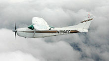
Taking the rear seat out of our Cessna, we loaded the plane with bicycles and camping gear, intent on a two-week cross-country adventure to the west coast and back.
Our itinerary after departing Columbus, Indiana on the morning of May 17, 1985, included Hot Springs, AK; San Antonia, TX; El Paso, TX; Grand Canyon National Park, AZ; Palm Springs, CA; Santa Catalina Island, CA; Death Valley, CA; Salt Lake City, UT; Ogalala, NE, Rockford, IL; then home.
Hot Springs
Hot Springs was a mid-point stop on our way to my business meeting in San Antonio. Commercial airline travel often involves hours involved at the terminal for check-in, luggage handling, departure waiting and then the reverse of it on arrival. Often the time in airport terminals exceeds the time in the air. The advantage of having our bicycles with us meant that after parking the airplane and ordering fuel for the next leg, we would be on our way within minutes.
Hot Springs gets its name from forty-seven superheated springs discovered in 1673 that bubble up to the surface retaining a temperature of 143 degrees. The therapeutic value of hot water baths led to the development of a successful spa in Arkansas in 1832.
Even more popular than the hot waters were the ten major casinos that flourished in early 1920s. Gangsters flocked to Hot Springs, and killings became commonplace. Law enforcement was paid off to look the other way. Eventually, gambling was closed down in 1967.
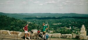
After biking the streets of the city, occasionally stopping to test the temperature of the water in the creeks, “Yeow, it’s hot!” we rode to the top of the surrounding Ouachita Mountain. Marveling at the bird’s eye view of the metropolis below. Eric said, “isn’t it interesting that having flown in at 8,000 feet, we are now awestruck at an elevation of 1,000 feet above that town?” Go figure.
The next morning it was on the San Antonio.
San Antonio
While I worked hard at the convention, attending cocktail parties, receptions, and schmoozing with vendors, Eric joined his mother, who had flown out commercially, and did the Alamo, River Walk and enjoyed other touristy sights.
After three days of business stuff, Eric and I departed, beginning the real adventure.
El Paso
I had considered flying into Mexico, however, entering Mexican airspace could be thorny and I did not want to risk having my airplane stuck on the wrong side of the Rio Grande, so landed at a Texas airport near the border. We did however walk across the boundary into Juarez.
In the past I have visited beautiful Mexican cities like Guadalajara and Mexico City, but all border towns seem to have shabby neighborhoods, noisy honky-tonks, and ornery looking hombres. After a quick meal of genuine tostados, Eric and I returned to the USA.
Grand Canyon National Park
Flying across New Mexico and Arizona we were mostly over unpopulated open prairies. Visual Flight Rules allows flying 500 feet over such areas but one must still be alert for rising hills, cell towers, and power lines. In the Navy we called flying at tree top heights, “flat hatting.” I’m not sure where that expression comes from.
One of my fellow flight students once returned from a flat hatting flight and was immediately reprimanded. He wondered who saw him and how he got caught. He then learned it was the leaves and branches sticking out of the leading edges of his wings that gave him away.
We didn’t get that low but did have to check out a canoe on a river and two cowgirls riding across the plains.
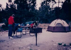
After landing at Grand Canyon Airport, we loaded the bikes with tent, sleeping bags, and camping gear and peddled off to find the park’s campground.
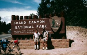
The road we were on paralleled the canyon, but we did not stop to take in the view. Finally, we had to check it out. Holy cow what a sight! The enormity of its depth and width was staggering. Grand Canyou is huge, or dare I say GRAND. It measures 277 miles long, as much as 6,000 feet deep, and ten miles across in places. But it was the rich variety of red, orange, and gold colors that provoked your “Wow.” There must be a more descriptive exclamation than “Wow,” but both of us stood there open-mouthed, expressing that very word. Just remarkable.
Climbing back on our bikes, we needed to get to the campground, but couldn’t ride more than five minutes without needing to again take in that wonderous sight.
That night at our campfire, under a canopy of stars more brilliant than ever before experienced, Eric said, “For the rest of this trip, if we don’t see another sight a tenth as beautiful as the Grand Canyon, just being here today makes it all worthwhile.”
Amen to that!
The next day we hiked into the canyon on the Bright Angel Trail. Climbing back up would take twice as long as going down, so our plan was to hike down for one hour before turning around. There were fifteen or twenty other hikers spread out in front and behind us. At rest stops we became acquainted. Among them were a honeymooning couple, a mother and two teen age daughters—each wearing open toed sandals, and Pops, an overweight, overdressed grandfather, not wanting to be there except at the insistence of his 6-year-old-grandson who darted back and forth, knocking into people as he passed.
Going down we all moved at a fairly common pace. However, after turning around, the group started struggling. Pops was hurting. Collapsed on a rock, his long sleeve shirt soaked in sweat, he said, “When I catch that grandson of mine, I’m going to kill him.” There were rangers stationed along the trail and we told the first one we came to he might want to check on the old guy back on the rock behind us.
We spent the rest of the day peddling along the South Rim and marveling at the vistas.
Upon departure the following day, I decided to take advantage of a once-in-a-lifetime opportunity and fly into the canyon below the rim. Indeed, it was a timely opportunity because shortly after our visit the FAA prohibited flights over and into the canyon. There had been accidents over the years. In 1956 a DC-7 and Super Constellation collided killing all aboard. It was speculated the pilots were treating passengers to views of the canyon. In 1980 a twin-engine plane and a helicopter carrying sightseers collided killing 25 people. Both were below the rim at the time of the collision.
Flying over the rim and reducing the throttle to descend was a physically and mentally unpleasant experience. Would the plane respond when I applied power to level off? Why did the engine sound so rough? This was no place for carburetor ice or the hundred other things that could cause an engine problem. An emergency landing here was not possible.
I was not having fun. I’ve made landings in instrument conditions with an engine out in snow and ice, and this was equally as stressful. But Eric was loving it. “Look Dad at the mule train. They’re waving at us. Can we go lower?”
“No way! We’re out of here and on to Palm Springs.”
Palm Springs
After landing in Palm Springs, Eric and I popped out of the cockpit expecting to inhale dry desert air and were practically slammed back into our seats by the humidity. I asked the lineman, “Where is that dry climate I always hear about?”
“It’s those damn golf courses,” he said, “Irrigation systems. Hell, we got more golf courses than traffic lights in this town. Every week you read about a new course being built.”
There were no campgrounds in Palm Springs, so Eric and I hopped on our bikes to tour the city and find a cheap motel.
Palm Springs was beautiful. Every street corner had an explosion of colorful flowers. The boulevards were lined on both sides with fifty-foot royal palm trees. Landscapers in clean white coveralls were manicuring the lawns and gardens of the lovely homes we were passing. We started counting the Rolls Royces, Bentleys and other luxury cars on the road but they soon became too numerous to hardly notice.
We found a Howard Johnson’s motel but paid three times what other accommodations had cost. I decided I could not afford to live in Palm Springs.
Next day we would be flying across Los Angeles on our way off the coast to Santa Catalina Island.
Across Los Angeles
L.A. is one of the busiest air traffic areas in the country. I could have filed an instrument flight plan and been in direct contact with air traffic controllers but there is a visual flight corridor through the area and since Santa Catalina is only 20 miles off the coast I opted to depend on my eyes in the sky. Bad idea.
I had heard about the smog of Los Angeles but when taking off in the blue skies over Palm Springs, didn’t give it much thought. We soon found ourselves flying into pea soup as I struggled to see the airliners I was listening to in my headset. This was not good and I immediately began to climb attempting to find clear air.
My Skylane has a service ceiling of 18,000 feet however above 10,000 oxygen becomes a requirement … and we didn’t have any. The requirement is if between 10,000 and 12,000 feet for more than 30 minutes, oxygen is required. I was at 12,500 feet before we were out of the soup and it would be another 10 minutes before we were over the Pacific and descending for the landing on Santa Catalina.
I told Eric, “If you see me slumped over, I hope you remember those flying lessons I gave you as an eight-year-old.”
Suddenly the air cleared, but only to reveal a buildup of puffy white clouds. We needed to find a hole in the clouds to get down to what I assumed was a sea level airport. Finding a hole, I lowered the wheels and flaps for drag and dove near vertically toward the Pacific Ocean.
We broke free of the clouds at 1,000 feet just a few miles from Catalina. Unfortunately, the island appeared to be surround by rocky cliffs. It was here I must admit pilot error. This experienced pilot took a closer look at his chart and saw the airport, named “Airport in the Sky” was on top of a plateau on Catalina at 1,600 feet. We needed to find that hole again and climb back on top.
Okay, there it was, with just 3,000 feet of runway, both the approach end and far end at the cliff’s edge. Eric’s advice was, “Dad, a landing neither too short nor too long would be advisable.”
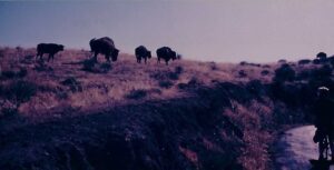
The ride on our bikes 1,600 feet down to the waterfront town of Avalon was breathtaking, especially when we came around a hairpin curve and saw a herd of buffalo in the middle of the road. What? Buffalo? There are no buffalo in California. The buffalo we learned were brought to Catalina in 1924 for the filming of the silent movie The Vanishing American. The herd multiplied and was periodically removed to the plains, but 150 of the head were kept on the island as curiosities.
Catalina was fascinating and one could spend many days there enjoying the beaches, the casinos, the dance halls, the sailing, and the hiking, but our plan was to have a fine seafood dinner that night and depart in the next morning for a short flight to Death Valley.
So, did we ride 1,600 feet back up to the Airport in The Sky? What, are you kidding? We hired a van.
Death Valley
I looked forward to landing at Death Valley and watching my altimeter go below zero. Death Valley is the second lowest point in the western Hemisphere, 282 feet below sea level. It’s the hottest and driest place in North America.
After landing and opening the cockpit door, it was like opening the door to a super-heated oven. Yikes. The airport looked abandoned with one little beat up Piper Cub rusting away on the ramp. There was, however, a restroom and a telephone to call for fuel.
Eric used the restroom and when he returned to the plane said, “Dad, even the water in the toilet is hot.” I didn’t ask how he knew that.
We weren’t going to spend the night in Death Valley but did walk to a park visitor’s center which had a very interesting museum.
So how did Death Valley get its name? In 1849 a wagon train of gold-seekers became lost in the valley and couldn’t find their way out. They were forced to eat several of their oxen and used wood from their wagons to cook the meat. Several of the pioneers died. A few were eventually able to hike out. As they left, one of the women turned and said, “Goodbye, Death Valley.”
We flew out that afternoon heading for Salt Lake City.
Salt Lake City
Salt Lake is surrounded on the northwest by the Wasatch and Oquirrh mountain ranges. Flying in between the peaks at 10,000 feet, the tower asked if I could make a straight in approach to landing. The runway was practically under our nose.
“No problem. Hang on Eric, this is going to be a dive bomber run to landing.” Again, like our failed approach to Catalina I lowered the wheels, dropped the flaps and did a vertical dive toward the runway. We touched down on the last half of the concrete. Welcome to Salt Lake City.
Eric and I found accommodations and then biked around the city, enjoying its clean, uncluttered ambiance. The streets were wide, as directed by its founder, Brigham Young. He wanted them wide enough that a wagon team could turn around without the driver resorting to profanity.
Temple Square is the iconic symbol of Salt Lake containing the Mormon Temple, built between 1864 and 1867. The Temple tabernacle is where the famed Mormon Choir performs.
Built before the advent of electronics and amplifying systems, Young chose an elliptical design so that sound from the pulpit could be concentrated and projected to the opposite end of the building. That was demonstrated by a coin being dropped on the wooden floor at one end of the tabernacle and being clearly heard 250 feet away. The tabernacle’s organ, the largest in the world, had 11,633 pipes.
Eric and I were then treated to a performance of the magnificent Mormon Tabernacle Choir. The 360-member, all volunteer choir has been in existence since the tabernacle was built, 150-years earlier. Members, many being husbands and wives, are allowed to belong for twenty years or until reaching 60-years of age to give new members a chance to join. The choir is famous for its many albums, concerts, and world travels. It has performed for ten presidents, sung at six inaugurations, won two Peabody Awards, two Freedom Foundation Awards, three Emmys, and numerous other honors and recognitions.
I have heard the choir on recordings, radio, and television a number of times, but to be in that hall with the organ playing and those 360 voices singing is an incredible experience. It moved both Eric and me with awe and wonder.
“Dad, remember what I said about Grand Canyon? This is even more inspiring.”
I can’t help but think that experience had a lot to do with my son becoming the conductor of the Indianapolis Symphonic Choir. He has since conducted at Carnegie Hall, Kennedy Center, and other venues around the world.
Salt Lake was definitely one of the highlights of our magic carpet adventure. We were now heading home. The weather up until then had been incredibly cooperative. Other than that smog over L.A., the weather as we said in the Navy was “CAVU” (Clear and visibility unlimited).
Leaving Salt Lake, we had our first forecast of Inclement conditions. Moving in from the West Coast, a low pressure system with accompanying thunderstorms was heading our way. Our next planned stop was Ogallala, Nebraska, which had a campground by a large lake.
I filed a flight plan out of Salt Lake and was in constant communication with Air Traffic Controllers. Close behind us I could see the dark skies.
After landing and using double tie downs, we loaded up the bikes with camping gear and started out for the ten-mile ride to the campground with storm clouds close behind us.
Thunderstorms in Nebraska can be extremely violent. Loaded down as we were, racing up the highway was not easy. The clouds gained on us, their color changing from dark gray to black to a mixture of purple. The storm was rolling across the plains like a freight train. The winds first blew sideways and then head-on, almost bringing us to a stop.
“Come on, Eric. It’s just a couple more miles.”
“Just trying not to overrun you, old man.”
We arrived at the campground office just as the rain began to fall in torrents. Fortunately, It only lasted 45 minutes. After registering for a camp site, Eric and I set up our tent, soon to be dry in the now sunny and warm breezes.
How incredibly fortunate we had been. No mechanical problems, no weather issues other than the near miss in Nebraska, and now with one more stop for fuel in Rockford, Illinois, we would be home. What sights we had seen and fun we had. The Skylane’s tachometer indicated thirty-eight flight hours. We had been gone fourteen days and covered five thousand miles. My barnstorming fantasy had been fulfilled. It had indeed been a magic carpet experience, and how great to share the experience with one of my sons.
Sounds like a wonder adventure! The Grand Canyon sounds amazing. Great pictures, too.